Azimuth
Advertisement
Mkon's SatCalc v.0.5
SatCalc is a free software which calculates Azimuth and Elevation for geostationary satellites used for television broadcast. Features include the calculation of the LNB skew and calculation of sun outage which occurs in spring and fall.
Advertisement
SatCalc v.1 2
You can enter your City/State OR Zipcode and it outputs a lot of useful information like Azimuth, Elevation, Latitude, Longitude, and Magnetic Deviation.
Astro Helper v.0.0.1 beta
Astro Helper will tell you the angle of elevation above the horizon (altitude) and the direction in degrees from North (Azimuth) of the selected objects.
WGS-84 Calculator v.1.10.0.14
WGS-84 Calculator is used to calculate geodetic distance and azimuth between two points (latitude and longitude). In addition, it can calculate a new point from origin using the given azimuth and distance.
Local Coordinates Model v.1.0
Displays the position of a star in local (Altitude/Azimuth) coordinates. Local Coordinates model displays the position of a star in local (Altitude/Azimuth) coordinates. The horizon is shown along with the four cardinal directions (N, E, S, and W).

ARTools v.1.0.0.0
Simple application to assist ham radio operators. It contains QTH locator tool with distance and azimuth calculations,
HUD_1_FLY v.1.0.0.0
Head Up Display,Artificial horizon, gps, roll and azimuth indicator of the aircraft, air speed indicator, altitude, flight coordinates, augmented reality Help landings. Latitude, Longitude, Pager in map, Speed in meters per second and knots, Altitude
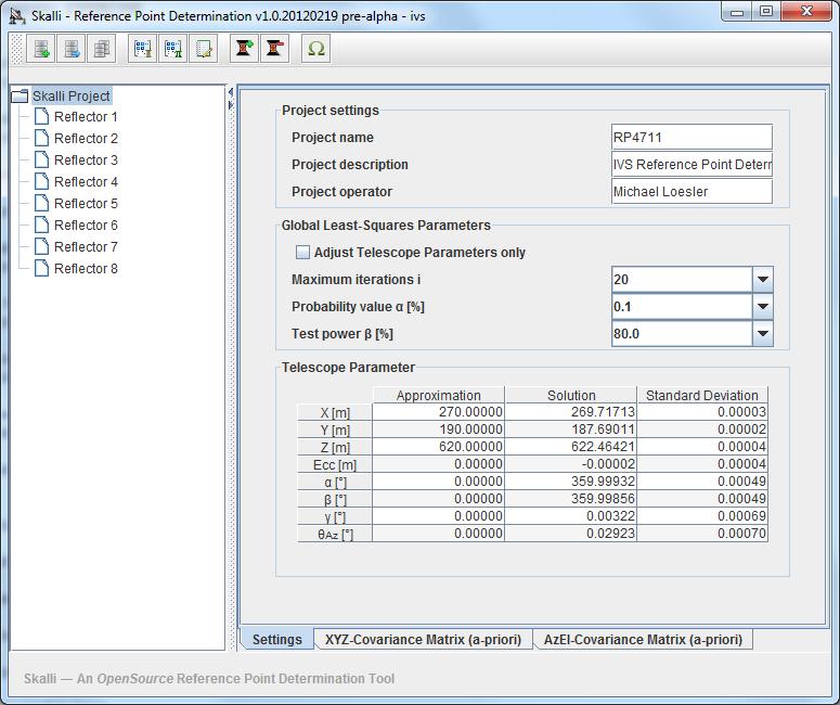
Skalli v.20120428
Skalli is a simple tool to estimate the IVS reference point of an azimuth-elevation type VLBI radio telescope.
Satellite Antenna Alignment v.2.99.0.0
The program "Satellite Antenna Alignment" is used to calculate the angles necessary for installing satellite dishes. The main difference from similar software is the possibility to calculate the position for all satellites at once.
Eye4Software GPS Toolkit
Toolkit to add GPS functionality to software (GPS SDK). All NMEA0183 protocol versions are supported, all NMEA 0183 can be filtered by NMEA type and talker ID. Information on GPS status can also be retrieved: GPS fix quality, Satellites used in fix, DGPS
AstroNav v.1.1.6
Combine multiple sights on different tracks. Data available for 9999BC to 9999AD including a Star Atlas, twilights and eclipses. It will print conventional Nautical Almanac pages while the voyage plan is a sophisticated tool in its own right.