Azimuth
Solmetric SunEye v.4.55.3936
SunEye is an integrated Shade Analysis Tool for solar site assessment. It includes a fish eye camera and a dedicated on-board processor to perform digital image processing and analysis to compute shading and solar access percentages.
Heavenly-Opportunity v.3 4
Do you want to be prepared when you visit a new photo location? Want to plan your trip to catch the full rising moon?
Blue Marble Desktop v.2. 2. 2001
The Blue Marble Desktop is the all in one geospatial data management platform for Blue Marble's popular data transformation tools.
ASF SAR Training Processor v.1. 1. 2010
The SAR Training Processor (STP) is a graphical tool written to assist in learning and teaching the flow of SAR processing. After installation, you will have a start-menu shortcut that you can use to run the SAR Training Processor.
IslandParadise v.6.0
Island Paradise shows you PathTransition, Timeline animation, and path elements that build specialized shapes. (The sun moves along an elliptical path created with path element ArcTo.
HNSKY v.2 3
HNSKY 2.30 is a program that puts a planetarium in your computer's screen. Hallo Northern Sky (this is the complete name) includes 26000 deepsky objects, all stars to magnitude 12, all planets and moons, along with hundreds of asteroids and comets.
GSky Digest v.0.4
gSky Digest is an application which informs you concisely about any astronomical event of the visible sky which is happening in your vicinity. This lightweight application provides the positions of various objects of the solar system.
The Photographer's Ephemeris v.1.0.6
The Photographer's Ephemeris (TPE) is a tool to help with the planning of all types of outdoor photography, but particularly landscape and urban scenes.
FAGPS 0.8.x v.1.0
System ForAnn GPS allows tracking and location of your phone or phone of your friends / family. You can watch real-time position of many phones simultaneously. You can run it even on the cheapest phones with Bluetooth port, which allows the
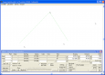
Copan Lite v.11 11
Land surveyors and civil engineers: o Calculate surveys and manage points, effortlessly o Run Copan on Windows 2K/XP/Vista/7 o Use it forever and pay nothing o Choose quadrant bearings or N/S azimuths, and gons or DMS o Create point files
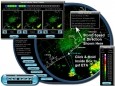
StormPredator v.2 60
StormPredator provides personal near real-time NEXRAD doppler radar images from any location in the USA on your PC desktop. It has an EXCLUSIVE storm tracker and predictor tool,
VisualGPS v.4.2 Build 105
VisualGPS (Freeware) incorporates many advanced features found in professional programs. Its sole purpose is to display graphically specific NMEA 0183 sentences and show the effects of selective availability (SA). VisualGPS is a general purpose